Super Bowl Sunday forecast: 15 million under winter storm alerts
Written by ABC Audio All Rights Reserved on February 9, 2025

More than 15 million people across a large portion of the nation were under winter storm alerts on Super Bowl Sunday morning, with many digging out from snow left by the first of three storms forecast to slam the U.S. through Thursday.
Snow was continuing to fall in upper New England on Sunday morning, with Boston expecting to get a total of 6 to 8 inches of snow from the weekend storm. Residents of northern Massachusetts are bracing for 8 to 12 inches before the snow tapers off around midday.
Many of the winter alerts are expected to expire by midmorning Sunday, while others will linger into the early afternoon.
Preliminary overnight snow totals showed Medford, Wisconsin, receiving 13 inches of snow, while 8 inches fell in Andover, Minnesota, and Cadillac, Michigan. New York City’s Central Park recorded 3 inches of snow and Minneapolis got 3.3 inches.
Sunday’s Super Bowl between defending NFL champs the Kansas City Chiefs and the Philadelphia Eagles will be played inside New Orleans’ climate-controlled Caesars Superdome and will not be affected by a chance of passing rain around the 6:30 p.m. ET kickoff.
On Saturday, New Orleans hit 85 degrees, tying a daily high-temperature record. Sunday is expected to bring a mix of sun and clouds to the Big Easy and temperatures are expected to reach near 77.
Elsewhere, people were digging out on Sunday from the snowstorm that socked the Midwest and the Northeast on Saturday night into Sunday morning.
But a reprieve from the snow will be short-lived for many people across the country as two more storms are lining up and threatening to bring heavy rain and possible flash flooding to the South and more snow to the Midwest and Northeast.
Lake-effect snow warnings for Fair Haven and Oswego, New York, go into effect at 4 p.m. ET Sunday and are expected to last into Tuesday. Up to 16 inches of snow is forecast for the upstate New York area.
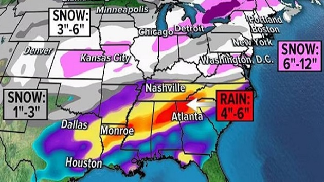
The next storm is expected to develop on Monday over Texas and Oklahoma before pushing into the Midwest on Tuesday with rain south of the Ohio River and snow generally north of it. In the areas that see rain, there is a chance for flash flooding on Tuesday from north Louisiana to southeastern Tennessee — or from Shreveport to Atlanta. The rain is expected to last for hours before the atmospheric faucet shuts off.
By Tuesday night, the storm is forecast to bring snow to the mid-Atlantic and Northeast. The storm will likely dump the heaviest snow on Washington, D.C., which is expected to get around 6 inches possibly by sunrise Wednesday. Philadelphia could also get 3 to 6 inches of snow, and an inch to 3 inches is forecast from New York City to Boston.
Yet another storm is expected to arrive on Wednesday across the Great Plains and bring heavy snow to Nebraska, Colorado and Kansas. The storm is expected to spread east on Wednesday to Missouri, Iowa, Illinois, Michigan and Indiana. Chicago could see snow for about 20 hours from Wednesday morning into early Thursday.
The storm will likely just bring rain to the mid-Atlantic states as the snow line will be farther north, where snow is expected again for Boston and upstate New York on Thursday morning.
Copyright © 2025, ABC Audio. All rights reserved.
 KVSP
KVSP 


